
Generating hillshade
Compute a shaded relief with your choice of sun azimuth, altitude and z factor, show it on its own or blended into the colours, and export it.
You will learn
- Compute hillshade and understand its values.
- Choose sun azimuth, altitude and z factor.
- Blend hillshade into other colourings and export it.
Prerequisites
Data for this tutorial
Nanda Devi massif, SRTM (real terrain) Download nanda-devi-srtm-1arcsec.tif
- Format
- GeoTIFF, 1 band, Int16, Deflate, tiled
- CRS
- EPSG:4326 (WGS 84, longitude/latitude)
- Content
- Elevations 2285 to 7801 m above the EGM96 geoid; lon 79.7276 to 79.9776, lat 30.2279 to 30.4779
- In Orbis3D
- Data panel ▸ Sample data ▸ Nanda Devi massif, SRTM (real terrain) ▸ Load
- Licence
- SRTM 1 arc-second, NASA/USGS, public domain
Synthetic samples are CC0 1.0; the SRTM sample is public domain. About the datasets
The task
You want a classic grey shaded relief of Nanda Devi, lit from the north-west, both as a view and as a raster for a map.
How hillshade is computed
Hillshade is the brightness of the ground under a distant sun: the cosine of the angle between the surface's normal and the direction of the sun. Orbis3D uses the slopes from Horn's method (as for slope):
hillshade = (sin(alt) − cos(alt) · (dz/dx · sin(az) + dz/dy · cos(az))) / √(1 + (dz/dx)² + (dz/dy)²)
The result runs from 0 (facing away from the sun, in shade) to 1 (facing the sun). Negative values (self-shadowed slopes) become 0. Cast shadows from neighbouring ridges are not part of hillshade; use Scene ▸ Lighting ▸ Cast shadows for those in the 3D view.
Steps
- Load Nanda Devi massif.
- Open Analysis ▸ Hillshade. The defaults are Sun azimuth 315° (north-west), Sun altitude 45°, Z factor 1 and Compute edges on.
- Click Show hillshade (or Compute hillshade). The terrain turns grey, lit from the north-west.
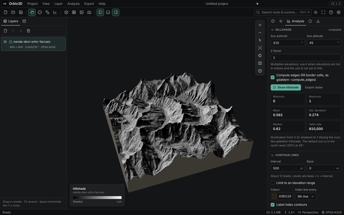
- Change the sun: a lower altitude (for example 25°) gives more contrast; an azimuth of 315° keeps the illusion that ridges stand up. Lighting from the south (around 135°–225°) often makes valleys look like ridges.
- Raise the Z factor (for example 2) to strengthen the shading of gentle terrain.
- To combine the relief with colours, go to the Surface tab, choose Colour by ▸ Elevation (or slope) and set Blend over colours under Hillshade. Orbis3D uses this blend at 45 % by default.
- Export the hillshade with Export raster: as GeoTIFF it is a Byte raster from 1 (shade) to 255 (lit) with 0 as NoData, the same encoding as
gdaldem hillshade.
Expected result
A grey relief with bright north-west-facing slopes and dark south-east-facing slopes. The mean illumination of Nanda Devi is 0.58 with the default sun.
Notes
- The hillshade sun (Analysis or Surface tab) and the 3D sun (Scene ▸ Lighting) are separate. Match hillshade sun in the Scene tab aligns them.
- Orbis3D's hillshade agrees with
gdaldem hillshadeto within one grey level in the test suite.
Common mistakes
- Relief looks inverted. The sun is in the south. Use an azimuth between 270° and 360°.
- Very flat result. The DEM is gentle or in feet. Raise the z factor or set the elevation unit.