
Tutorial datasets
The data used by the tutorials. The valley datasets are synthetic: they were generated for teaching, describe no real place, and must not be used for real decisions. The Nanda Devi DEM is real terrain cropped from the SRTM 1 arc-second survey.
Licences: the synthetic datasets are released under CC0 1.0 Universal (public domain dedication): copy, change and share them for any purpose. The SRTM data is in the public domain (NASA and USGS); a credit such as “SRTM data courtesy of NASA/USGS” is welcome. Most datasets can be opened inside Orbis3D without downloading: open the Data panel and choose Sample data.
Sample valley DEM (synthetic) Download orbis3d-sample-valley.tif
- Format
- GeoTIFF, 1 band, Float32, Deflate, tiled
- CRS
- EPSG:32643 (WGS 84 / UTM zone 43N)
- Content
- Elevations 419.5 to 1452.5 m; NoData -9999 in the south-west corner
- In Orbis3D
- Data panel ▸ Sample data ▸ Sample valley DEM (synthetic) ▸ Load
- Licence
- Synthetic, CC0 1.0
A river valley with a ridge and a peak, 480 × 360 cells of 30 m, with a NoData corner. Used in: Understanding the interface, Importing your first DEM, Understanding DEM metadata and NoData, Vertical exaggeration, Wireframe visualization, Working with multiple terrain layers, Creating contour lines, Measuring distances and inspecting coordinates, Texture draping, Exporting GLB models, Exporting OBJ models, Saving and restoring projects.
Sample valley, later survey (synthetic) Download orbis3d-sample-valley-2026.tif
- Format
- GeoTIFF, 1 band, Float32, Deflate, tiled
- CRS
- EPSG:32643 (WGS 84 / UTM zone 43N)
- Content
- Elevations 419.5 to 1452.5 m; quarry about 28 m deep, landslide deposit about 11 m thick
- In Orbis3D
- Data panel ▸ Sample data ▸ Sample valley, later survey (synthetic) ▸ Load
- Licence
- Synthetic, CC0 1.0
The same valley after a quarry pit was dug and a landslide moved material downslope. Use it with the first DEM to compare surfaces. Used in: Working with multiple terrain layers.
Sample valley, ASCII Grid (synthetic) Download orbis3d-sample-valley-60m.asc Download orbis3d-sample-valley-60m.prj
- Format
- ESRI ASCII Grid (.asc) with .prj
- CRS
- EPSG:32643 (WGS 84 / UTM zone 43N)
- Content
- 240 × 180 cells of 60 m; NODATA_value -9999
- In Orbis3D
- Download it, then open it with Project ▸ Open files
- Licence
- Synthetic, CC0 1.0
The valley at 60 m as an ESRI ASCII Grid with its .prj file. Used in: Supported formats, Understanding coordinate systems and units.
Sample land cover image (synthetic) Download orbis3d-sample-landcover.png Download orbis3d-sample-landcover.pgw
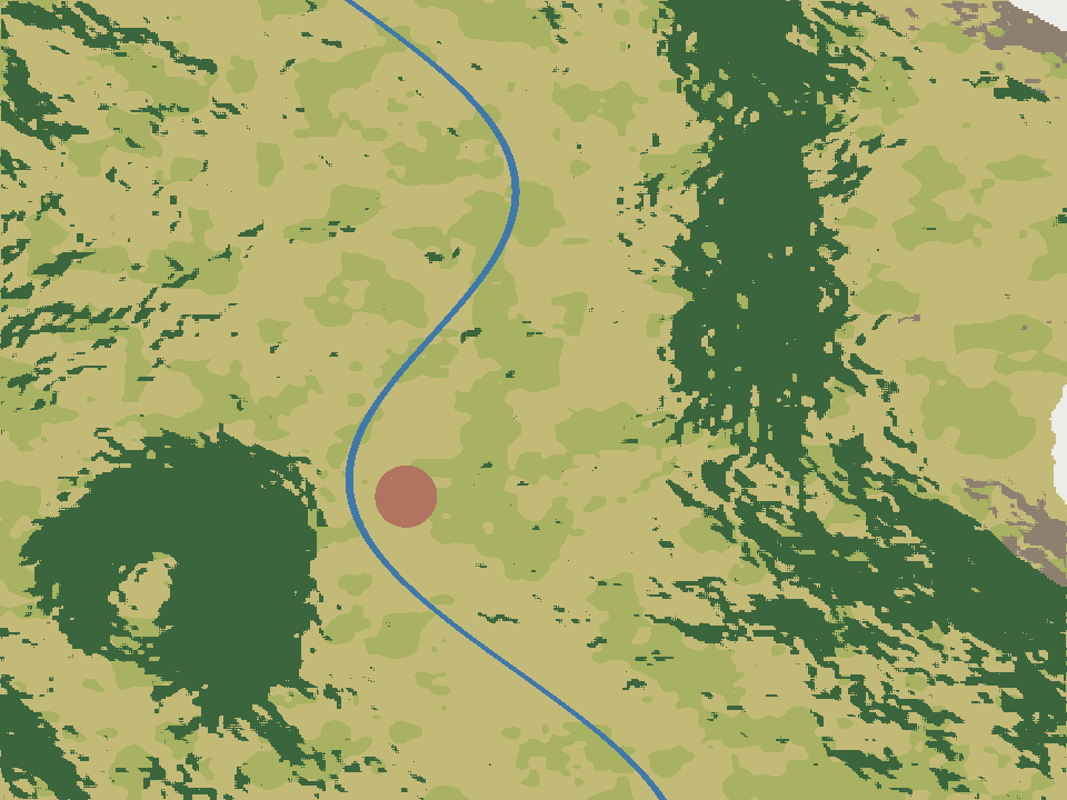
- Format
- PNG (RGB) with world file (.pgw)
- CRS
- EPSG:32643 (same as the valley DEM)
- Content
- 960 × 720 pixels of 15 m: fields, forest, rock, snow, settlement and river
- In Orbis3D
- Data panel ▸ Sample data ▸ Sample land cover image (synthetic) ▸ Load
- Licence
- Synthetic, CC0 1.0
A land cover map of the sample valley to drape over the terrain, with a world file that places it in UTM 43N. Used in: Texture draping.
Nanda Devi massif, SRTM (real terrain) Download nanda-devi-srtm-1arcsec.tif
- Format
- GeoTIFF, 1 band, Int16, Deflate, tiled
- CRS
- EPSG:4326 (WGS 84, longitude/latitude)
- Content
- Elevations 2285 to 7801 m above the EGM96 geoid; lon 79.7276 to 79.9776, lat 30.2279 to 30.4779
- In Orbis3D
- Data panel ▸ Sample data ▸ Nanda Devi massif, SRTM (real terrain) ▸ Load
- Licence
- SRTM 1 arc-second, NASA/USGS, public domain
Real terrain of the Nanda Devi area in the Garhwal Himalaya, 900 × 900 cells of 1 arc-second (about 30 m). Used in: Introduction to Orbis3D, Understanding the 3D viewport, Camera navigation, Changing terrain colours, Terrain lighting and shading, Performing slope analysis, Performing aspect analysis, Generating hillshade, Generating elevation profiles, Understanding terrain statistics, Optimizing terrain resolution, Exporting screenshots, Exporting CSV analysis results.
Larger real data
To practise with large rasters (Working with large DEM datasets), use public elevation models such as the Copernicus DEM GLO-30 tiles (Cloud Optimized GeoTIFFs, free under the Copernicus DEM licence) or SRTM 1 arc-second tiles from NASA Earthdata or USGS EarthExplorer. Download a file to your computer, then open it in Orbis3D; Orbis3D never downloads data on its own.