
Working with large DEM datasets
How Orbis3D reads large rasters progressively, uses Cloud Optimized GeoTIFF overviews, stays within memory, and what you can do when a file is too large.
You will learn
- What happens when you open a large DEM.
- Why Cloud Optimized GeoTIFFs open fastest.
- How to choose the processing resolution and handle memory limits.
Prerequisites
The task
You have a 1° Copernicus GLO-30 tile: 3,600 × 3,600 cells (13 million elevations, 42 MB). You want to view and analyse it in the browser without running out of memory.
What happens when you open a large DEM
- Preview. Orbis3D first reads a small version of about 65,000 cells (256 × 256), builds the terrain and shows it. A Preview badge appears next to the layer name.
- Refinement. It then reads the working grid: the raster reduced to fit the processing budget, 4 million cells by default (about 2,000 × 2,000 for a square tile). The terrain and colours are rebuilt and the badge disappears.
- Analysis (slope, contours, profiles …) uses the working grid.
Reading is done in blocks of rows, and each working cell is the average of the source cells it covers, ignoring NoData. The whole full-resolution raster is never held in memory at once.
Cloud Optimized GeoTIFFs
A Cloud Optimized GeoTIFF (COG) is tiled and contains overviews: reduced copies at 1/2, 1/4, 1/8 … of the resolution. Orbis3D reads the smallest overview that is still at least as large as what it needs, so the preview comes from a tiny overview and the working grid from a medium one. The Info tab shows COG next to the format and lists the number of overviews.
In Orbis3D's automated browser test, the 3,600 × 3,600 Copernicus COG showed its preview after about six seconds (including handing the 42 MB file to the browser) and was refined to 2,000 × 2,000 cells about five seconds later, using headless Chromium with software rendering. A computer with a graphics card is usually faster.
## Steps- Open a large GeoTIFF as usual. Watch the progress under the layer name; the status bar tells you whether an overview or the full resolution is being read.
- To stop a slow refinement, click the cross next to the layer. The layer stays at preview resolution.
- Open Settings (gear button) to change the budgets.
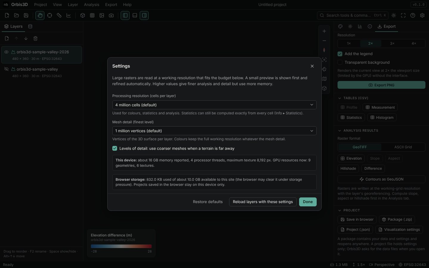
- Processing resolution (cells per layer): 1, 4 (default), 9, 16 or 36 million cells.
- Mesh detail (finest level): 250,000 to 4 million vertices.
- Levels of detail: coarser meshes when a terrain is far away.
- Click Reload layers with these settings to read the open layers again.
- For exact numbers from every cell, use Info ▸ Statistics ▸ Compute exact statistics.
Limits
- Orbis3D does not promise unlimited sizes. The browser's memory, the graphics memory and the GPU's texture size are the limits. If memory runs out, Orbis3D stops and asks you to lower the processing resolution.
- ASCII Grid and SRTM HGT files are read completely, because these formats cannot be read in blocks. ASCII Grids larger than 200 million cells are refused; convert them to a tiled GeoTIFF.
- Orbis3D opens files from your computer only. It does not download rasters from the internet.
Common mistakes
- Raising the budget on a phone. Phones start with 1 million cells for a reason. Raise it only on a computer with plenty of memory.
- Expecting full detail from a reduced grid. Check the working grid size in Info ▸ Processing.